
Geography students’ data mining helps with Florida forest conservation
Posted:
A remote sensing geography class from Bloomsburg University played a key role in the conservation of a 14-acre southern Florida forest home to protected wildlife that’s been fending off urban and commercial development for the past 60 years.
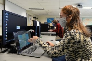
In November, the Boynton Beach City Commission turned down a developer’s bid to purchase the land where it planned to build nearly 100 single-family homes. The residents’ plea to save Nickels Forest was aided by the proposed data analysis of area satellite imagery by Bloomsburg students this past fall for their Remote Sensing of the Environment class. Their professor presented to the commission a plan to analyze urban growth and reduction of green cover with Nickels Forest being the center of focus.
“The project was a great introduction to real-world applications of remote sensing,” says Caitlin Guerin, a geography and planning major who’s pursuing minors in spatial analysis and geographic information science (GIS), and geosciences. “It was incredible to think our research helped persuade the local government to cease actions to remove the forest. I hope to apply (this experience) to future conservation efforts.”
The class was drawn to the Palm Beach County situation through the awareness of BU’s Department of Environmental, Geographical and Geological Sciences of the increased activism in Boynton Beach due to the proposed land sale. An opportunity to leverage their data mining skills and apply what they were learning in class was hard to pass up, students say.
“Data mining and my interest in remote sensing was like picking up a new hobby,” says Brett Voloshin, a geography and planning major who’s pursuing a minor in GIS and spatial analysis. “Everyone starts a new hobby with a bit of research and hands-on testing before really getting into it. Data mining is like doing that initial research, and how long it takes really depends on how thorough your research is. It might take a while or little time at all to find data worth using.”
Voloshin adds, “Meanwhile, my interest in remote sensing grew as I learned more about it. Having the skills to work with the software and run these analyses have really opened a lot of new doors for me in terms of a career.”
To help the city commission’s looming decision on the developer’s land offer, the Bloomsburg professor reached out to the mayor and fellow elected officials via email offering assistance in helping them levy an increased data-influenced decision — using satellite imagery to quantify Palm Beach County’s changes in impervious surfaces and natural habitats over the past six decades. Nickels Forest is home to several state protected species, including gopher tortoises.
Overall, the class project entailed:
- data mining Landsat and Sentinel satellite imagery, as well as aerial imagery
- learning about Florida land cover and exploring ground photographs
- classifying satellite imagery
- accuracy assessing results with vintage aerial imagery
- improving classifications
- storing data and documentation in a well-organized GIS database for researchers
“Remote sensing taught me (the many) capabilities of satellite data,” Guerin says. “In my previous GIS courses, I always liked to apply satellite imagery base maps to my assignments, but there’s so much more you can do with a satellite image — it’s incredible really.”
By using the Earth Resources and Data Analysis System (ERDAS) image processing software, Guerin says one can visualize sediment movement, ocean currents, deforestation, and more.
“(NASA’s Earth Observation System) mission satellites have provided an uninterrupted record of earth’s surface for the past 48 years,” Guerin says. “And this invaluable documentation is available to the public! In my future endeavors, if landscape analysis needs to be executed, I’ll turn to the resources I learned about during (this class).”
Through its collective work, the class was able to show that more remote sensing and data mining needs to be done on the area for more accurate satellite image classifications, particularly to aid proper municipal approval process for future land development.
A majority of the council voted in November to preserve Nickels Forest and cease development prospects, with the caveat that a plan needs to be developed for removal of invasive species and remedying local sewer issues.
“In this project, we utilized data mining to find patterns, anomalies, and correlations to make predictions,” says Matilda Svensson, a geography and planning major who’s pursuing a minor in spatial analysis and GIS. “This is something that’s a big part of remote sensing as you constantly look at past and present imagery to do a wide spectrum of things like study urban growth over a period, analyze the land cover in a specific area and find cool features, as well as many other uses.”
She adds, “It’s very cool stuff, and it’s something I’m considering as a career. These skillsets would be useful for a lot of different careers.”
Not only did the semester-long project offer the students a real-world application to their classroom learning but also a chance to make an impact for a community’s conservation efforts — even one located more than 1,000 miles away.
“This research brought a sense of realism and urgency to my work,” Voloshin says. “Knowing this project will have a tangible impact creates a sense of urgency that the faster we can finish this project the better chance we have at aiding the continued protection of the forest.”
Over winter break students continued their remote sensing work and this spring, students say they’ll work to improve on the satellite image classifications they’ve started by creating regionally-based rules to be used in all classifications. There’s always something new to learn, according to Guerin.
“Remote sensing and GIS are invaluable tools in today’s world,” Guerin says. “They’re marketable skills not only in earth sciences, but in economics, education, medicine, and more. I recently attended an American Association of Geographers Conference and spoke with a doctor of epidemiology who pursued a master’s in GIS to further her understanding of her field. These tools enable people to gain a better understanding of their discipline over space and time.”
The Nickels Forest project has since morphed into special topics work that will continue with upcoming remote sensing classes, as well as provide opportunities for collaborative research, and foster relationships with alumni as several soon-to-be graduating students plan to remain active on the project.
Svensson is among them who envision greater things beyond this class experience.
“This field is a great way to make an impact,” Svensson says. “There are so many things you can do, and there are many career paths you can take that utilize remote sensing skills. There are many companies and agencies that value spatial analysis and the associated benefits, especially today.”
Categories:
You May Also Like
Alumnus to Discuss Rock Picks
Dr. Brian F. Platt ’01, Associate Professor of Geology and Geological Engineering at The University of Mississippi, will be the keynote speaker at the College of Science and Technology Research Day on...
CU-Bloomsburg FBLA on Road to National Leadership Conference
Photo Caption: From left, first row: Kyla Groller, Kimberly Speece, Aviel Kuhn, Amanda Kaczmarczyk, Madeliene Mamourian, Madison O'Brien, Julianne Emberger. Second row: Olivia Whitaker, Mackenzie...
Senator Haywood and Commonwealth University promote college access with expo
PHILADELPHIA – Commonwealth University and Pennsylvania State Sen. Art Haywood (PA-4) partnered to host a college expo for more than 150 high school students at Enon Tabernacle Church on Monday, April...